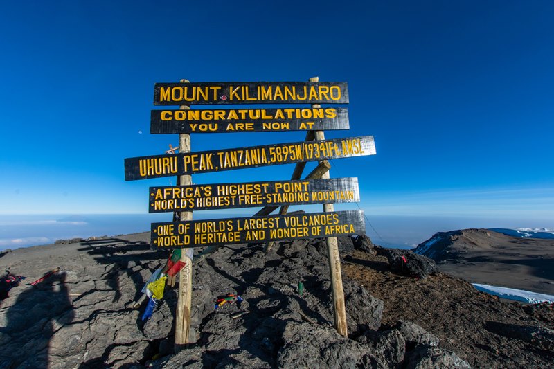
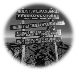
5,895 meters! |
|||||||||||||||||||||||||||
Kilimanjaro is a dormant Volcano located in the north of Tanzania. Named "The rooftop of Africa", the summit really towers above the flat Tanzanian landscape and hosts immaculate glaciers which are unfortunately shrinking further every year. Hikers get their first glimpse at the Volcano upon landing at Kilimanjaro Airport! |
|||||||||||||||||||||||||||
Every year, it is estimated that about 35,000 hikers attempt the summit, with an average success rate of 70%. With a summit (Uhuru peak) at 5,895 meters above sea level, altitude sickness is a real danger and the trek up has to be done in several days to acclimatize and reduce effects of Acute Mountain Sickness which unfortunately claims the lives of hikers every year. The Time of Useful Consciousness as defined in Aerospace Standards shows that at 6,000 meters, the body deteriorates rapidly and affects adversely functional capacities after only 10 minutes! In order to reduce risk, the climb is done in 5 to 9 days depending on the route chosen to allow the body to acclimatize and give a change to hikers to reach the summit safely. |
*Adapted from Fundamentals of Aerospace Medicine |
||||||||||||||||||||||||||
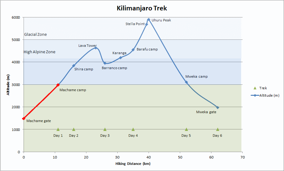
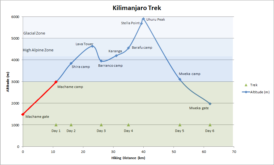
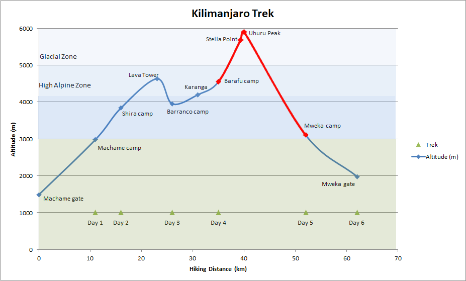
We decided to go for the Machame Route, a beautiful 6 days trail, which offers some of the best views, provides great acclimatization, and does not make you trek back from where you came from! Here is the map of the Machame Route: |
|||||||||||||||||||||||||||
Summary of the climb: The Machame Route starts at 1,800m above sea level, right in the lush Rainforest. From there, it is a steady climb up to Shira Camp which is reached on the 2nd day afternoon. On the 3rd day, the trek goes through the moorlands, up to Lava Tower for acclimatization, and then back down to 4,000m to sleep. This little detour to Lava Tower is a game changer for acclimatization, and allowed us to avoid all the Altitude Sickness symptoms which usual come at night. The fourth day is a gradual climb to the base camp (Barafu) located at 4,600m. The toughest day is on the 5th day, a day which start at midnight for the 7-hours climb to the summit, followed by 2 hours back down to the base camp, and another 3 to Mweka Camp! Overall, we did not feel Altitude sickness mostly because we climbed slowly ("Pole-Pole", and took-in a lot of water!
|
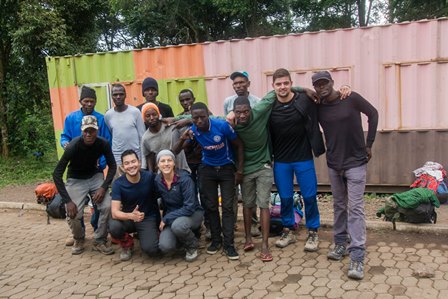
Kilimanjaro National Park charges high Climbing permit fees, and it is compulsory to climb with at least a guide. All guides are certified and go through specific trainings. Because the trek is 6 days long, porters are engaged to carry the food, the tents and any extra luggage you may have. With temperatures going as low as -20C at the summit, there are quite a lot of gear to bring on this trek! Each porter is allowed to carry a maximum (and very well regulated) load of 15kg. As such, the beginning of the trek starts with a bit of a wait as the guide settles the lengthy admin paper work process, and organizes the trekking party by hiring the right amount of porters based on the total weight of the expedition. There was 3 of us in our group, assisted by our fantastic guide Julius, his assistant guide Armani, and the cook Elasto. On top of these guys, we had 4 porters each bringing the total expedition to about 15 people!! Weighting at the beginning of the trek. (Each porter is capped to 15Kg load)
Our fantastic guide Julius (left) and our great team of Porters (right)!
|


Return to top |
Rainforest |
||
 |
About the climb |
|
 |
Rainforest |
|
|
Moorland |
|
|
Summit |
|
The first part of the Machame Route is through lush rainforest, an environment not unlike what can be found in Indonesia or on Borneo! Day 1 and Day 2 are spent at the "lower" altitudes, on the green part of the Volcano. |
Day 1 |
|
||||||||
|
|||||||||
The Machame Route starts at 1,800 meters above sea-level, in a beautiful lush rainforest with tall trees and dense vegetation. The trail exits the rainforest on the 2nd Day, upon arrival on the Moor Plateau where Shira Camp is located. The first day of the trek is nor very long not very steep. Being mostly under the lush canopy of the Jungle, it doesn't get too hot. However, on this first day, the trail pierced through the cloud base layer, and as such, some portions were a bit damp! The path is not very steep and very well marked. The lush and dense jungle is really fascinating! Didn't spot many animals though except a few monkeys near the gates:
The trail to Machame Camp is full of vegetation, including the beautiful endemic Kilimanjaro Impatience Flower (Left) and few bright red Gladiolus watsonioides (Right) in contrast to the very green surroundings:
After a few hours of rather easy trekking, we reach the Machame Camp and go straight to the ranger hut for what will become a habit: the signing-in to the camp! Although the camp is still at low altitude and still located in the rainforest zone, it is possible to see the top of Kilimanjaro, and some of its legendary snows!
|
|||||||||


Return to top |
Day 2 |
|
||||||||
|
|||||||||
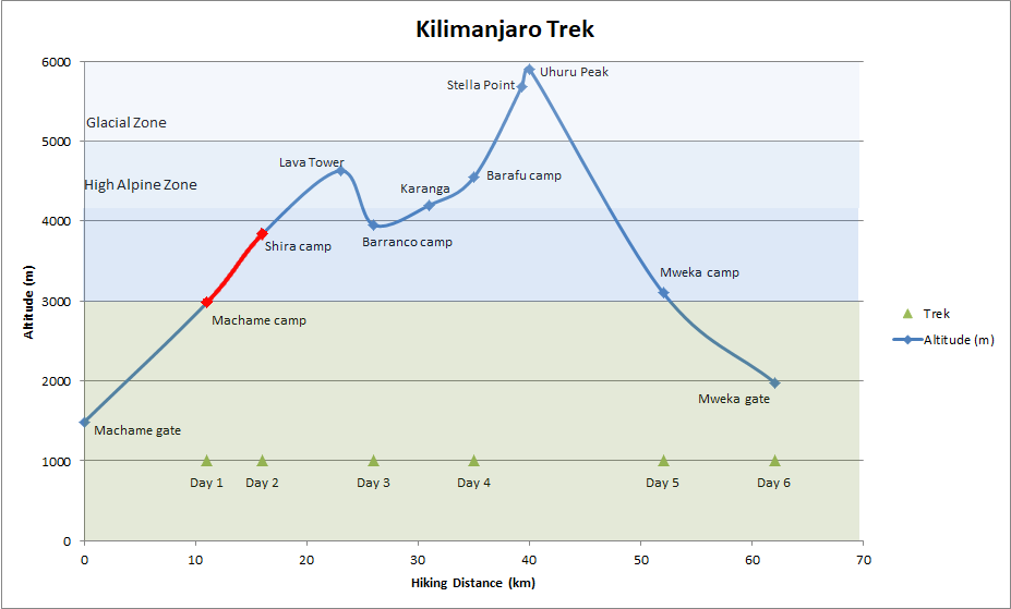
The second day of the trek is the shortest day with only 5km trek and 860m climb. On this day however, the trail clearly detaches from the clouds, and offers stunning views on the rainforest slopes of Kilimanjaro. The cloud base being quite low, from the second day onwards, the trek above the clouds is spectacular!
On the way up, the vegetation does evolve to more Alpine trees, deformed by the constant winds rushing down the mountain. Lonely yellow/red "red-hot poker" flower decorate the rock trails!
Upon arrival to the Shira Camp, the landscape switches to moorlands, which have a very lunar feel! The large caldera is a beautiful backdrop to the desertic landscape!
Shira Camp was reached early, and the rest of the afternoon was spent relaxing, sipping tea, and exploring the camp for the best views on the Kilimanjaro. Shira camp being located on a plateau, it offers absolutely fantastic views on Mount Meru, as well as spectacular sunsets!!
Because of the altitude and the exposure to the wind, the night is quite cold, and the first morning lights reveal frost everywhere! We were lucky to have the full moon, which helped greatly for the evening toilet break!
|
|||||||||


Return to top |
Moorland |
||
|
About the climb |
|
|
Rainforest |
|
|
Moorland |
|
|
Summit |
|
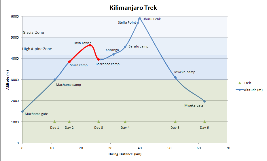
The second part of the Machame Route is through an amazing Alpine environment with beautiful views on both the clouds below, and the Kilimanjaro snows on top! Day 3 and Day 4 are spent trekking at high altitudes; between 3,000m and 4,600m. The Machame route is particularly good for acclimatization as it follows one of the main mountaineering rules: "climb high, sleep low"! |
Day 3 |
|
||||||||
|
|||||||||
The third day of the Machame Route is a key step to good acclimatization. The first part of the trek is a very regular and not very steep path which slowly tales hikers to the top of Lava Tower, at 4,630m. The landscape is totally lunar, and during this entire part of the trek, hikers get to enjoy great views on Kilimanjaro summit! A gradual upwards climb to Lava Tower
Soaring above the clouds!
Lava Tower is a great location to have lunch, and spend as much time as possible for the body to get used to the reduced Oxygen partial pressure. From Lava tower, it is a steep 2 hours descent to the Camp 3,100m, with fantastic views on the clouds below, and with the return of vegetation when reaching camp! (Including the impressive giant groundsels, endemic to Kilimanjaro)
Be warned! Barranco Camp is locate on a valley which means that sunlight disappears early, and won't appear in the morning! With a sloping plateau, the wind gets strong, and the evening is cold!
|
|||||||||


Return to top |
Day 4 |
|
||||||||
|
|||||||||
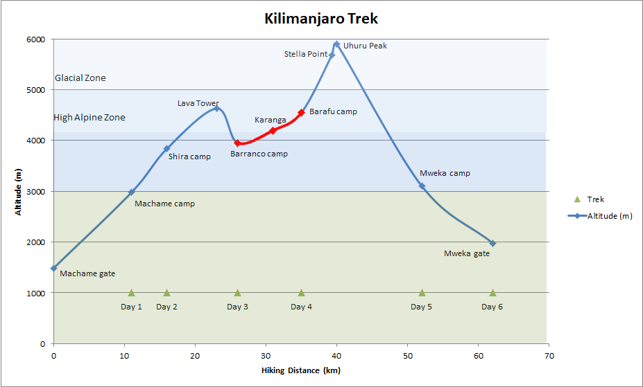
The fourth day of the Machame Route starts with the climbing of the fantastic Barranco Wall! Although its a very steep climb, we actually really enjoyed it, the landscapes are great and it is really a steep climb which ends on a ridge with a breathtaking view on Tanzania below! Morning climb of Barranco Wall, quite literally a wall of rocks overlooking the Barranco Camp!
Upon reaching the ridge, the view is just breathtaking!
After Barranco Ridge, it is a regular slope all the way to Karanga Camp where some hikers stay one night to acclimatize. We went directly to the base camp and did not feel like waiting one day at Karanga would have made any difference! On Karanga Camp, the food is brought up by some porters from Mweka so we got serve some great fresh Chicken! Tip: Eat as much as you can at Karanga because if Altitude Sickness hits you, you probably won't be able to take-in much at the base camp before the final climb!
And after a fantastic lunch, we made to the base camp which we reached at about 3pm. The base camp is located at 4,550 meters above sea level. From there, the summit does seem close enough! However, it is more than 1,000 meters higher! A fantastic place to see the summit, and get prepared physically and mentally for the final climb!
|
|||||||||


Return to top |
The Summit |
||
|
About the climb |
|
|
Rainforest |
|
|
Moorland |
|
|
Summit |
|
THE Summit... It had been on our mind for many many months! Many times had we imagined waking up at midnight, putting our warmest clothes on, and getting out of the tents into the windy and icy night to start the climb! We had spare batteries for our head lamps, down jackets for the -15 to -20C expected to the top, wind-stopper, few layers of shirts and trousers, gloves and 3 liters of water! (For info, the platypus-type water containers are not of much use on the climb as the water just freezes inside... ) |
Day 5 |
|
||||||||
|
|||||||||
The climb to the summit starts at midnight, and is pretty much a non-stop 6-7 hours climb to Stella Point. The gradient is not as steep as Volcanoes we had done in Asia such as the Rinjani in Indonesia - 3,726 m - (See here) or Mount Malchin - 4,050 m - in Mongolia (See here) but the Altitude changes everything. The trick is to really go slowly (and keep your heart rate under control) and drink lots of water (to get some extra O2 from the water). This will avoid headaches, and will ensure that you are not panting too hard, a situation that can rapidly deteriorate as you can't really catch your breath, and your body just heats up and tires out gapping for air. By keeping things nice and slow, we did not actually feel any adverse effects due to Altitude! Can't say that of a French girl who passed out in front of us, and who was rushed down by two guides who were quite literally sprinting down the slopes! We were lucky to have the Full moon on our climb, making it a surreal experience!
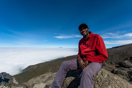
From Stella point, it is a simple 800m walk to the summit, with beautiful sunrise lights revealing the last remaining legendary glaciers of Kilimanjaro!
The Caldera of the dormant volcano is actually really large and totally lunar! Absolutely no vegetation or living thing up here! At 5,895m, it is strongly recommended to stay no longer than 15-20mins as anything can happen, and the body can collapse all in a sudden due to lack of Oxygen going to the brain. As such, with much regrets, we quickly started the descent back to the Base Camp with, again, stunning views on the clouds below! We reached the camp after a 3 hours descent.
|
|||||||||


Return to top |
Day 6 |
|
||||||||
|
|||||||||
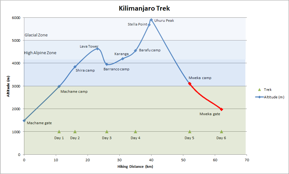
After a quick rest at the base camp, the trek continues down to safer altitudes, all the way to Mweka Camp, another 1,450m down! This final descent during the 5th Day is fairly tiring, and takes 3 hours at least, but its really a fantastic experience to hike, in one day, from a deadly Glacial Summit down to a humid camp back into the lush rainforest! The 6th day started with a nice cup of tea and warm Uji (a local porridge made of maize flour), and an enjoyable 3 hours trek to the Mweka Gate. The trek ends with a last presence signature at the ranger hut. The Kilimanjaro trek was a great physical challenge and a unique experience, hiking above the clouds and seeing the sun rise from the highest point of the entire African Continent. It was great to learn so much about the volcano, Tanzania, and spend quality time with Julius and his fantastic team!
|
|||||||||

Return to top |
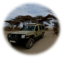
Continue your trip in Tanzania with us:
After a week above the clouds, head with us deep into Tanzanian wilderness to see some of the most beautiful animals on the planet and understand the fragile ecosystem which allows them to survive!
|
|||
|
|||
|
|||
Return to top |